Community Project Archive

  • Onondaga Earth Corps Tree Mapping

    Started: December 14, 2023

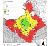
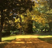
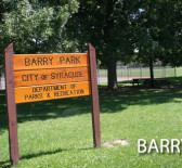
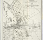
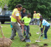
    In 2023, student interns worked with the Onondaga Earth Corps (OEC) to create maps of OEC’s impact on the Syracuse urban tree canopy and celebrate the organization’s 20th year anniversary. OEC runs a [ … ]

  • Morningside Cultural Trail Kiosk Map

    Started: November 2, 2022    /   Ended: June 10, 2015

    In 2022, Syracuse Community Geography students worked with Paul Harvey, a local urban trail enthusiast, to update a trail map for the Morningside Cultural Trails. The Morningside trail network includes over 7 miles [ … ]

  • New Clark City Situationer

    Started: October 31, 2022    /   Ended: March 31, 2021

    This situationer provides a detailed discussion of the New Clark City (NCC) as an influential project that threatens the communities living within and around its area. Through spatial analysis, this document shows the [ … ]

  • Onondaga County Municipal Zoning

    Started: May 20, 2022

    In 2022, Syracuse Community Geography interns partnered with CNY Fair Housing and SOCPA to create digital shapefiles for municipal zoning in Onondaga County. Shapefiles and Map PDFs are available at the town and [ … ]

  • Transforming Vacant Land into Sites of Food Production

    Started: December 15, 2021

    Urban gardening and farming increase access to food production, which is a basic principle of food sovereignty. Syracuse currently has 29 active community gardens and urban farms and the Greater Syracuse Landbank has approximately [ … ]

  • Supporting Farm to School Implementation in Syracuse, NY

    Started: September 1, 2021

    Research is needed to develop sustainable relationships between farmers willing to grow and sell produce, the Syracuse City School District (SCSD), processors, aggregators, and other actors in the greater Farm to School landscape. [ … ]

  • Morningside Cultural Trails Maps

    Started: September 1, 2021

    Syracuse Community Geographers began working with Paul Harvey and neighborhood groups on Syracuse’s eastside to create the Morningside Cultural Trail Maps in 2015. Over time, the number of trail maps have expanded and [ … ]

  • Barry Park Community Input Study

    Started: September 26, 2017

    In spring 2017, the University Neighborhood Preservation Association and the City of Syracuse Department of Parks, Recreation, and Youth Programming partnered with Syracuse Community Geography to conduct a community input study about Barry [ … ]

  • Syracuse's Historic Water System 1892-1896: Story Map

    Started: February 1, 2016    /   Ended: January 2, 2016

    Water is a vital resource. It benefits the health, growth, and security of a city. Yet for Syracuse, New York, a post-industrial city, water infrastructure, often a peripheral investment, poses a major concern. [ … ]

  • CNY Land Trust Mapping

    Started: December 16, 2015

    In Fall 2015, Syracuse Community Geography began a partnership with the Central New York Land Trust (CNYLT) to create a GIS map inventory of the land trust’s nature preserves. CNYLT is a member-driven, [ … ]

  • Minority or Women Owned Small Businesses in Central New York

    Started: May 29, 2015

    CenterState CEO is working with a group of minority community and business leaders to help them launch a Minority Chamber of Commerce within the CNY region (tentatively called the Minority Economic Alliance, or [ … ]

  • Access to Financial Services in Syracuse, NY

    Started: February 15, 2015    /   Ended: July 7, 2015

    In collaboration with Syracuse Cooperative Federal Credit Union, students in the Spring 2015 Community Geography class conducted a GIS-based analysis to help the credit union better understand its impact on the Syracuse community. [ … ]

  • A Neighborhood Profile of NEHDA's Service Area

    Started: February 15, 2015    /   Ended: June 11, 2015

    In Spring of 2015, Syracuse Community Geography worked in collaboration with the Northeast Hawley Development Association, Inc., a not-for-profit community housing development agency committed to revitalizing and stabilizing Syracuse’s northeast sector. U.S. Census [ … ]

  • Syracuse's Historic Brewing Legacy

    Started: February 1, 2015    /   Ended: August 25, 2015

    The Onondaga Historical Association (OHA) is dedicated to exploring, communicating, and celebrating Onondaga County’s rich cultural history. Partnering with OHA, students in the Spring 2015 Community Geography course developed creative materials that narrate [ … ]

  • Manufacturers in Central New York

    Started: January 28, 2015

    Northside Urban Partnership is expanding its workforce development programs to reach more Northside residents. Syracuse Community Geography was tasked to identify potential manufacturing employment sites in Central New York. A list of manufacturing sites [ … ]

  • Refugee Urban Agriculture Story Map

    Started: August 24, 2014    /   Ended: August 1, 2015

    As a designated refugee resettlement city, the City of Syracuse has welcomed thousands of people from around the world fleeing political persecution, natural disaster and war. Refugees from countries including Bhutan, Burma, and [ … ]

  • GIS Data Updates for the Syracuse Parks Department

    Started: March 24, 2014    /   Ended: May 15, 2014

    Syracuse Community Geography was approached by the City of Syracuse Parks Department to update and refine their existing GIS files for the city’s 120 parks, community centers, playgrounds, fields, and green spaces. SCG [ … ]

  • Syracuse Hunger Project

    Started: October 23, 2013

    In 2003, the Samaritan Center of Syracuse, NY noticed an issue with food assistance programs in the city. All around Syracuse, food pantries were reporting an increase in demand for supplies. As a [ … ]

  • Syracuse Grows

    Started: October 23, 2013

    A result of the Syracuse Hunger Project’s ongoing work, Syracuse Grows is an organization which aims to lower food access problems by creating and maintaining community gardens. Community gardens provide gardeners with access [ … ]

  • Age-Friendly Central New York

    Started: September 24, 2013    /   Ended: January 14, 2014

    In Fall 2013, Syracuse Community Geography participated in an initiative spearheaded by FOCUS Greater Syracuse to develop a vision for an age-friendly Central New York. The goal of the project is to develop [ … ]

  • Census Workshop

    Started: September 12, 2013

    In 2012, Syracuse Community Geography began offering workshops to representatives of community-based organizations to help them better utilize U.S. Census Bureau data. Recent changes to the decennial census and the emergence of the [ … ]

  • Analyzing Housing Patterns in Auburn, NY

    Started: April 12, 2013

    In April 2013, The Fair Housing Council of Central NY (FHCCNY) requested the help of Syracuse Community Geography to analyze and map census data to further their cause. Based in Syracuse, NY, FHCCNY [ … ]

  • Child Care and Early Education Program Availability

    Started: January 30, 2013

    In spring 2013, students enrolled in the Community Geography course partnered with Child Care Solutions and P.E.A.C.E., Inc., to conduct a geographic analysis of home-based child care and Head Start program availability, demographic [ … ]

  • A Geographic Analysis of Urban Forestry Efforts in Syracuse, NY

    Started: January 30, 2013

    In partnership with the Cornell University Cooperative Extension of Onondaga County (CCE), students in the Spring 2013 Community Geography class conducted a geographic analysis of CCE’s urban forestry efforts in Syracuse, NY. The [ … ]

  • Housing Demolition, Vacancy and Tenure Patterns in Syracuse, NY

    Started: January 30, 2013

    In partnership with the City of Syracuse Bureau of Planning and Sustainability, students in the Spring 2013 Community Geography class conducted an analysis of housing demolition in Syracuse from 2002-2012. The city had [ … ]

  • Locating Quality and Affordable Housing

    Started: October 1, 2011

    Redrawing property boundaries required close collaboration with Housing Visions staff and specialized GIS parcel fabric tools. Building new quality and affordable housing is a crucial component of reviving neighborhoods in many U.S. legacy [ … ]

  • Onondaga County Literacy Mapping

    Started: September 12, 2007    /   Ended: December 11, 2007

    In 2007 the Family Literacy Alliance of Greater Syracuse (FLAGS) teamed up with Syracuse Community Geography to examine literacy in Onondaga County. The project aimed to identify, survey and map formal and informal [ … ]

  • Childcare in Onondaga County (2007)

    Started: October 1, 2006

    In 2006, Child Care Solutions partnered with Syracuse Community Geography to determine the geographic accessibility of child care in Onondaga County. They were curious if there were enough child care centers in Onondaga [ … ]