Community Project Archive

Category: Land Use

  • New Clark City Situationer

    Started: October 31, 2022    /   Ended: March 31, 2021

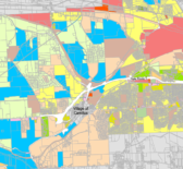
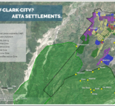
    This situationer provides a detailed discussion of the New Clark City (NCC) as an influential project that threatens the communities living within and around its area. Through spatial analysis, this document shows the [ … ]

  • Onondaga County Municipal Zoning

    Started: May 20, 2022

    In 2022, Syracuse Community Geography interns partnered with CNY Fair Housing and SOCPA to create digital shapefiles for municipal zoning in Onondaga County. Shapefiles and Map PDFs are available at the town and [ … ]

  • Morningside Cultural Trails Maps

    Started: September 1, 2021

    Syracuse Community Geographers began working with Paul Harvey and neighborhood groups on Syracuse’s eastside to create the Morningside Cultural Trail Maps in 2015. Over time, the number of trail maps have expanded and [ … ]

  • A Neighborhood Profile of NEHDA's Service Area

    Started: February 15, 2015    /   Ended: June 11, 2015

    In Spring of 2015, Syracuse Community Geography worked in collaboration with the Northeast Hawley Development Association, Inc., a not-for-profit community housing development agency committed to revitalizing and stabilizing Syracuse’s northeast sector. U.S. Census [ … ]

  • Syracuse's Historic Brewing Legacy

    Started: February 1, 2015    /   Ended: August 25, 2015

    The Onondaga Historical Association (OHA) is dedicated to exploring, communicating, and celebrating Onondaga County’s rich cultural history. Partnering with OHA, students in the Spring 2015 Community Geography course developed creative materials that narrate [ … ]

  • Housing Demolition, Vacancy and Tenure Patterns in Syracuse, NY

    Started: January 30, 2013

    In partnership with the City of Syracuse Bureau of Planning and Sustainability, students in the Spring 2013 Community Geography class conducted an analysis of housing demolition in Syracuse from 2002-2012. The city had [ … ]